The Unique Maps Co.
Old Map of Santa Cruz, California by USGS, 1954 – Monterey Bay & Pacific Coast Highway
Old Map of Santa Cruz, California by USGS, 1954 – Monterey Bay & Pacific Coast Highway
Não foi possível carregar a disponibilidade de retirada.
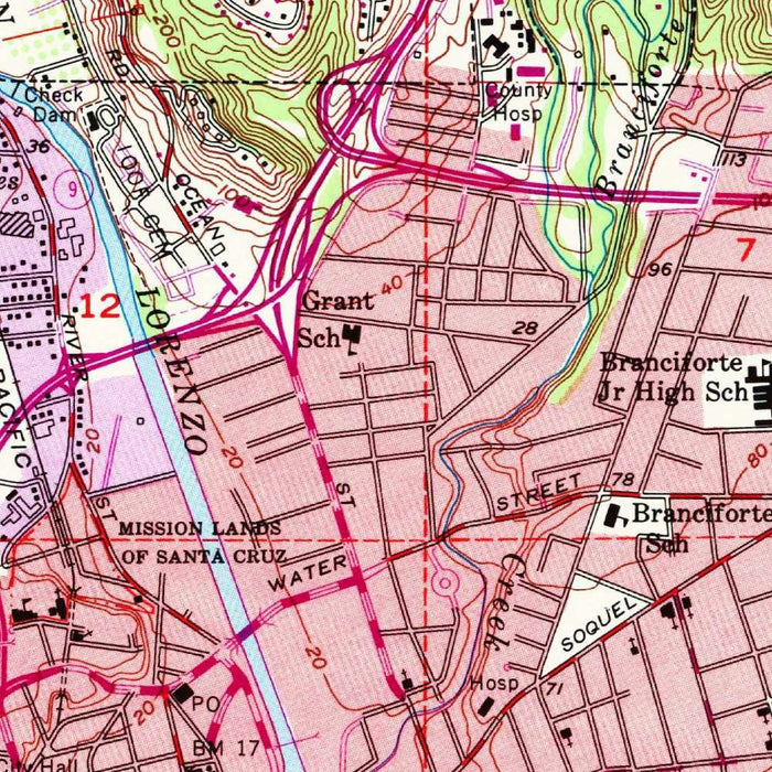
Published in 1982 from original 1954 topographic data, the United States Geological Survey’s “Santa Cruz” captures a celebrated stretch of the Central California coast at a revealing mid-century moment. At 1:24,000 scale, the map brings Santa Cruz into sharp cartographic focus: its gridded neighborhoods, curving shoreline, harbor approaches, principal roads, and the rising terrain that frames the city from behind. The sheet records a landscape balanced between seaside resort, working coastal town, and expanding urban community. Monterey Bay opens broadly to the south and east, while the Pacific edge is traced with careful attention to cliffs, beaches, and coastal landmarks. The result is both a navigational document and a historical portrait of Santa Cruz before later decades of growth transformed its civic and university landscapes.
The US Geological Survey, founded in 1879, became the preeminent American authority on scientific mapping, and this Santa Cruz sheet exemplifies the clarity and discipline of its postwar topographic style. Contour lines articulate the region’s hilly relief with quiet precision, translating ridges, slopes, terraces, and coastal bluffs into a readable visual language. Color distinguishes urbanized areas, vegetation, water, and terrain, while grid lines provide the practical structure necessary for survey, planning, engineering, and field use. Unlike decorative earlier maps, the USGS quadrangle is intentionally exacting, built for measurement as much as admiration. Yet its restrained design has its own elegance: a lucid interplay of line, tint, typography, and symbol that makes the complex geography of Santa Cruz immediately legible.
Santa Cruz itself appears as the map’s urban heart, arranged along key corridors such as Ocean Street, West Cliff Drive, and U.S. Route 1, the Pacific Coast Highway. These routes reveal the city’s relationship with both the inland valleys and the coast, connecting residential districts, commercial streets, recreational spaces, and the broader Central California road network. The map’s depiction of neighborhoods and minor streets offers a valuable glimpse of the city’s mid-century footprint, before subsequent suburban expansion and institutional growth reshaped the northwestern edge of town. Santa Cruz Harbor and the waterfront reinforce the city’s maritime identity, while parks and open areas show how recreation, tourism, and daily life were already intertwined with the coastal landscape.
The natural setting is especially compelling. Monterey Bay dominates the southern margin of the map, its sweeping curve contrasting with the intricate line of the Santa Cruz shoreline. West Cliff Drive, Needle Rock, and the meeting of land and sea are set against a backdrop of terraces and rising hills, a topography typical of this part of Central California where marine influences, uplifted landforms, and drainage patterns create dramatic local variation. The contouring makes visible the transition from low coastal ground to higher inland terrain, giving the viewer a strong sense of how the city is cradled between ocean and hills. This is a map not only of streets and settlements, but of the physical forces that shaped them.
As a historical document, the “Santa Cruz” quadrangle illuminates the city at a fascinating threshold. The 1954 data preserve a pre-late-century Santa Cruz, while the 1982 imprint places the map within a later era of environmental planning, infrastructure management, and renewed public interest in coastal land use. The approximate area later associated with the University of California, Santa Cruz—founded after the original survey data—adds particular historical resonance, underscoring how dramatically the city’s cultural and educational landscape would evolve. For collectors, planners, historians, and admirers of California’s coast, this map offers a richly layered view of place: a precise government survey, a record of urban development, and an evocative rendering of one of the state’s most distinctive coastal communities.
Cities, towns and places on this map
- Santa Cruz
- Santa Cruz Harbor
- Tenderloin area designation
- West Cliff Drive
- Ocean Street
- U.S. Route 1 / Pacific Coast Highway
- Pacific Ocean
- Monterey Bay
- Needle Rock
- University of California, Santa Cruz approximation
- Various parks and recreational areas
- Residential neighborhoods of Santa Cruz
- Major roadways and minor streets within the city
Historical context & cartographic details
- Produced by the United States Geological Survey / USGS.
- Historical 1:24,000 topographical map depicting Santa Cruz, California, and the surrounding area.
- Original map data dates from 1954; the map carries a 1982 imprint.
- Shows Santa Cruz as a populated place, including significant geographical and infrastructural features.
- Features contour lines to depict elevation.
- Uses distinct colors and gradients to indicate landforms, vegetation types, and elevation changes.
- Includes prominent grid lines to support navigation and map reading.
- Depicts hilly and coastal terrain typical of Central California.
- Clearly delineates urban areas and natural landscapes.
- Provides insight into mid-20th-century Santa Cruz, including urban development patterns and landscape changes over time.
Looking for a particular place? Review the detailed images to confirm that the town, landmark or feature you have in mind appears on the map. If you are unsure, ask our workshop to check before you order.
Detailed maps are especially rewarding at larger sizes, where names, boundaries and decorative features have more room to be appreciated. Use the close-up preview and size guide to choose the right scale for your wall.
This map looks amazing at sizes all the way up to 50in (125cm). If you are looking for a larger map, please get in touch.
The model in the listing images is holding the 24x36in (60x90cm) version of this map.
Where personalisation is available, you can add a short title or dedication, mark one meaningful place, or request one considered visual detail. See personalised map examples.
Every piece is printed to museum-grade archival standards using fade-resistant pigment inks on acid-free matte paper. Choose an unframed map print, framed map or canvas using the finish options above. Framed maps use crystal-clear optical acrylic and arrive ready to hang.
With its rich detail and strong sense of place, this map makes a considered gift for a new home, anniversary, retirement or anyone with a personal connection to the area shown. Still deciding? Explore our collection of rare old and vintage maps to discover another place, period or style.
Share