The Unique Maps Co.
Old Map of Rumson, New Jersey by USGS, 1954 – Red Bank, Long Branch & Sandy Hook
Old Map of Rumson, New Jersey by USGS, 1954 – Red Bank, Long Branch & Sandy Hook
Não foi possível carregar a disponibilidade de retirada.
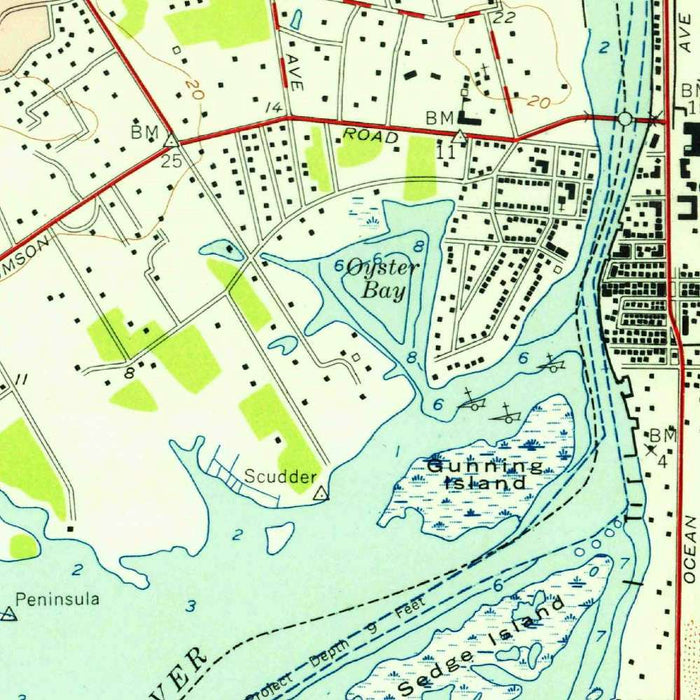
Published in 1956 from survey data gathered in 1954, the US Geological Survey’s “Long Branch” presents a finely detailed mid-century portrait of coastal Monmouth County, New Jersey. At a 1:24,000 scale, it gives particular attention to Rumson and its surrounding communities, balancing the precision of scientific survey work with the quiet drama of a shoreline landscape in transition. The map records a region where tidal rivers, barrier beaches, suburban streets, rail lines, and older village centers meet in close proximity. Its title evokes Long Branch, one of the Jersey Shore’s best-known seaside communities, yet the sheet’s real richness lies in its broader depiction of the Navesink and Shrewsbury river corridors, the Atlantic coast, and the expanding residential fabric of post-war New Jersey.
The US Geological Survey, founded in 1879, brought to this map the disciplined visual language that made its topographic sheets indispensable to engineers, planners, naturalists, and travelers. Contour lines, road classifications, waterways, railroads, and land-use coloring are arranged with the clarity and restraint characteristic of USGS cartography. Rather than offering decorative flourish, the map’s elegance comes from its exactness: the measured rise and fall of terrain, the crisp geometry of streets, the careful delineation of marsh, coast, and settlement. In this sense, “Long Branch” is both a practical survey document and a composed landscape study, showing how topography, transportation, and development shaped daily life along one of New Jersey’s most desirable coastal districts.
Rumson appears within a network of affluent river towns and shore communities, including Fair Haven, Little Silver, Red Bank, Shrewsbury, Oceanport, Deal, Bradley Beach, and Long Branch itself. The Shrewsbury River and Navesink River dominate the inland geography, their tidal channels and shorelines giving the area its distinctive peninsular character. To the east, the Atlantic Ocean defines the coastal edge, while Sandy Hook and nearby beaches hint at the broader maritime environment of northern Monmouth County. The map captures how water structured movement, settlement, and identity in the region: bridges, roadways, and rail connections thread between riverfront neighborhoods, commercial centers, and oceanfront resorts, revealing a landscape shaped as much by access and leisure as by natural form.
Historically, the sheet offers a valuable glimpse of the Jersey Shore during the 1950s, a decade of rapid suburban expansion following the Second World War. Established towns such as Red Bank and Long Branch are shown alongside growing residential areas, road networks, and transportation corridors that would continue to transform Monmouth County in subsequent decades. Routes 35 and 36, together with local roads and the Central Jersey Railroad, mark the infrastructure that connected shore communities to regional markets and metropolitan New York. The juxtaposition of urban blocks, open land, waterways, parks, and coastal stretches conveys a moment before later development intensified, making the map a revealing record of land use, mobility, and settlement patterns at mid-century.
The topographic character of the “Long Branch” sheet is subtle but deeply informative. Unlike mountainous maps where contour lines create dramatic relief, this coastal terrain speaks through modest elevations, river margins, beaches, wetlands, and built environments. The mapping of parks and green spaces, road grids, landmarks, and civic structures allows the viewer to trace the lived geography of the area: where communities clustered, where open land remained, and how natural corridors interrupted or guided suburban growth. Its restrained color scheme distinguishes developed zones, transportation lines, water features, and vegetation with admirable legibility. For collectors drawn to the history of New Jersey’s coast, this map captures Rumson and its neighboring shore towns at a pivotal moment of refinement, growth, and geographic change.
Cities, towns and places on this map
- Rumson
- Little Silver
- Fair Haven
- Red Bank
- Long Branch
- Shrewsbury
- Deal
- Bradley Beach
- Oceanport
- Sandy Hook
- Shrewsbury River
- Navesink River
- Monmouth County Park System
- Route 36
- Route 35
- Central Jersey Railroad
- Parks and green spaces
- Coastal areas along the Atlantic Ocean
- Notable landmarks and structures within urban areas
Historical context & cartographic details
- Produced by the US Geological Survey (USGS)
- Historical 1:24,000 topographical map based on 1954 survey data
- Issued with a 1956 imprint, capturing the region during the mid-20th century
- Shows the area during a period of post-war growth and changing land-use patterns in New Jersey
- Uses standard USGS topographic design, including contour lines to show elevation changes
- Employs color to distinguish different land uses, such as urban and agricultural areas
- Highlights the largely developed suburban landscape of the 1950s
- Reflects the USGS tradition of mapping land use, ecology, geography, and natural resources
Looking for a particular place? Review the detailed images to confirm that the town, landmark or feature you have in mind appears on the map. If you are unsure, ask our workshop to check before you order.
Detailed maps are especially rewarding at larger sizes, where names, boundaries and decorative features have more room to be appreciated. Use the close-up preview and size guide to choose the right scale for your wall.
This map looks amazing at sizes all the way up to 50in (125cm). If you are looking for a larger map, please get in touch.
The model in the listing images is holding the 16x16in (40x40cm) version of this map.
Where personalisation is available, you can add a short title or dedication, mark one meaningful place, or request one considered visual detail. See personalised map examples.
Every piece is printed to museum-grade archival standards using fade-resistant pigment inks on acid-free matte paper. Choose an unframed map print, framed map or canvas using the finish options above. Framed maps use crystal-clear optical acrylic and arrive ready to hang.
With its rich detail and strong sense of place, this map makes a considered gift for a new home, anniversary, retirement or anyone with a personal connection to the area shown. Still deciding? Explore our collection of rare old and vintage maps to discover another place, period or style.
Share