The Unique Maps Co.
Old Map of Pinetop-Lakeside, Arizona by USGS, 1961 – Show Low, Sitgreaves National Forest & Rainbow Lake
Old Map of Pinetop-Lakeside, Arizona by USGS, 1961 – Show Low, Sitgreaves National Forest & Rainbow Lake
Não foi possível carregar a disponibilidade de retirada.
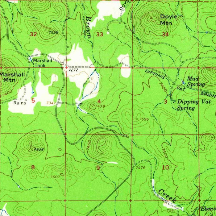
Titled “McNary Quadrangle,” this United States Geological Survey topographical map was published in 1963 using survey data from 1961, capturing a richly detailed portrait of Arizona’s White Mountains at a moment of mid-century change. Centered on McNary and the Pinetop-Lakeside area, the map records a high-elevation landscape far removed from the desert imagery often associated with the state. Its 1:62,500 scale allows both regional sweep and local precision, tracing roads, settlements, waterways, forest boundaries, and rugged relief. For collectors, it offers not only a technically refined USGS composition, but also a historical snapshot of communities and recreational landscapes just as modern development, tourism, and transportation were reshaping this cool, wooded corner of eastern Arizona.
The United States Geological Survey brought to this map the disciplined clarity that made its quadrangle series indispensable to engineers, geologists, foresters, planners, and explorers. Founded in 1879, the USGS became one of America’s great scientific mapping institutions, charged with documenting the nation’s terrain, water systems, mineral resources, and biological landscapes. In the “McNary Quadrangle,” that institutional precision is evident in the measured contouring, carefully labeled routes, and subtle differentiation of natural and built environments. The map’s green palette emphasizes wooded country and vegetated terrain, evoking the pine forests that define the region. Its style is practical, but also quietly elegant: a landscape translated into lines, symbols, and color with the authority of scientific observation.
Pinetop-Lakeside, prominently featured here, occupies one of Arizona’s most inviting mountain settings, known for cool summers, lakes, pine woods, and outdoor recreation. The map situates the community among places that have become closely associated with hiking, fishing, camping, and seasonal retreats, including Rainbow Lake, White Mountain Lake, Bonito Lake, and Fish Lake. Nearby Show Low appears as an important regional hub, while smaller names such as Indian Pine, Blue Ridge, Pineridge, Markham, and Clay Springs give the sheet a finely grained local character. The presence of Highway 260, U.S. Route 60, reservation roads, trails, and other pathways reveals a landscape connected by both modern travel corridors and older local routes through forest and upland terrain.
The topographic character of the map is especially compelling, with contour lines describing the folds, slopes, and uplands of a mountainous and hilly region. Black Canyon and the surrounding drainage patterns add drama to the terrain, while the broader setting within and near Sitgreaves National Forest underscores the area’s ecological richness. The White Mountains rise as an elevated refuge of ponderosa pine, lakes, meadows, and cooler air, a striking contrast to the arid basins and desert lowlands elsewhere in Arizona. Through its precise depiction of elevation and landform, the map communicates not merely location but physical experience: the climbs, ridges, watersheds, and forested expanses that shaped settlement, travel, and recreation in the region.
As a historical document, the “McNary Quadrangle” is particularly evocative because it records Pinetop-Lakeside and its surrounding communities before decades of subsequent growth and environmental change. Mid-century Arizona was entering a period of expanding road access, recreational development, and increasing interest in mountain retreats, and this map preserves the area’s geography at that threshold. Forest lands, lakes, reservation roads, and smaller settlements are shown in relation to emerging transportation routes and regional centers, offering insight into patterns of land use and movement. For anyone interested in Arizona history, USGS cartography, or the transformation of rural mountain communities, this map provides a refined and information-rich window onto the White Mountains in 1961.
Cities, towns and places on this map
- Pinetop-Lakeside
- McNary
- Show Low
- Indian Pine
- Sitgreaves National Forest
- Lakeside
- Blue Ridge
- Rainbow Lake
- White Mountain Lake
- Black Canyon
- Bonito Lake
- Pineridge
- Fish Lake
- Markham
- Greer
- Clay Springs
- Forest Lakes
- Highway 260
- U.S. Route 60
- Reservation roads
- Trails and other pathways
Historical context & cartographic details
- Map title: McNary Quadrangle
- Map type and scale: Historical 1:62,500 topographical map
- Date: Created using 1961 survey data and published with a 1963 imprint
- Publisher: Produced by the United States Geological Survey (USGS)
- USGS context: The USGS is a U.S. government scientific agency known for mapping, geology, hydrology, biology, and broader Earth science research
- Cartographic style: Uses a rich green color palette to show vegetation and terrain
- Topographic detail: Includes contour lines to represent elevation changes across mountainous and hilly terrain
- Historical significance: Valuable for understanding land use, environmental change, and urban development in the region since the early 1960s
Looking for a particular place? Review the detailed images to confirm that the town, landmark or feature you have in mind appears on the map. If you are unsure, ask our workshop to check before you order.
Detailed maps are especially rewarding at larger sizes, where names, boundaries and decorative features have more room to be appreciated. Use the close-up preview and size guide to choose the right scale for your wall.
This map looks amazing at sizes all the way up to 50in (125cm). If you are looking for a larger map, please get in touch.
The model in the listing images is holding the 16x20in (40x50cm) version of this map.
Where personalisation is available, you can add a short title or dedication, mark one meaningful place, or request one considered visual detail. See personalised map examples.
Every piece is printed to museum-grade archival standards using fade-resistant pigment inks on acid-free matte paper. Choose an unframed map print, framed map or canvas using the finish options above. Framed maps use crystal-clear optical acrylic and arrive ready to hang.
With its rich detail and strong sense of place, this map makes a considered gift for a new home, anniversary, retirement or anyone with a personal connection to the area shown. Still deciding? Explore our collection of rare old and vintage maps to discover another place, period or style.
Share