The Unique Maps Co.
Old Map of Lutsen, Minnesota by USGS, 1959 – Lake Superior, Lutsen Mountains & Cascade River
Old Map of Lutsen, Minnesota by USGS, 1959 – Lake Superior, Lutsen Mountains & Cascade River
Não foi possível carregar a disponibilidade de retirada.
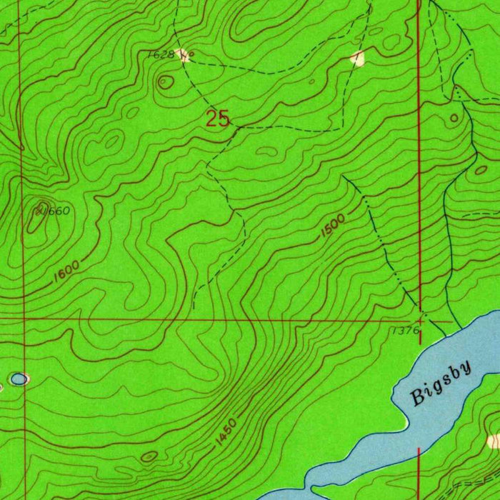
Published in 1960 from 1959 cartographic work, the US Geological Survey’s “Lutsen” captures a striking stretch of Minnesota’s North Shore at a moment when wilderness, recreation, and small-settlement life still met with remarkable immediacy. Centered on the populated place of Lutsen, the map situates this Lake Superior community within a dramatic landscape of ridges, river valleys, forest, and inland lakes. Its 1:24,000 topographical format gives the terrain an intimate precision, allowing roads, trails, waterways, and elevation changes to be read as part of a living regional portrait. More than a practical survey, it is a finely ordered record of Cook County’s mid-century geography, preserving the relationship between shoreline settlement and the rugged highlands rising behind it.
The US Geological Survey brought to this map the disciplined visual language that made its quadrangles indispensable to engineers, hikers, land managers, and historians alike. Founded in 1879, the USGS became the authoritative mapper of the American landscape, translating complex terrain into a standardized yet elegant system of contours, symbols, colors, and names. On “Lutsen,” that system is especially expressive: tight contour lines reveal the steep uplands near Lake Superior, while gentler spacing suggests forested basins and lake margins. Greens mark wooded land cover and blues articulate the region’s abundant water, creating a clear and graceful depiction of a place defined by both elevation and moisture. The result is cartography that is technical, readable, and quietly beautiful.
Lake Superior exerts a powerful presence over the map, not merely as a boundary of water but as the force shaping the settlement and movement patterns of the region. Lutsen’s proximity to the lake places it within one of the most storied corridors of the Upper Midwest, where Indigenous travel routes, fur trade pathways, logging activity, fishing communities, and later tourism all converged along the shore. Inland, the land rises quickly, and the map’s contours make that transition unmistakable. Rivers such as the Cascade cut through the terrain on their way toward Superior, carving valleys that provide both natural drama and practical routes through the hills. In this landscape, every road and trail appears negotiated with rock, forest, and water.
The inland lakes named around Lutsen—Poplar Lake, Barker Lake, Caribou Lake, Trapper’s Lake, Sawbill Lake, and Gunflint Lake—evoke the broader canoe country and forested lake district that has long defined northeastern Minnesota. These waters belong to a geography of portages, cabins, camps, and deep northern quiet, where glacially shaped basins interrupt the ridges and evergreen cover. The map also reflects the growing importance of outdoor recreation in the mid-twentieth century. Lutsen Mountains and the surrounding high ground would become closely associated with skiing, scenic travel, and North Shore tourism, while nearby Cascade River State Park preserved one of the area’s most dramatic river landscapes. The map records this region before later development fully reshaped its recreational identity.
As a historical document, “Lutsen” offers a compelling view of the North Shore in the late 1950s, when infrastructure remained comparatively sparse and the landscape’s natural forms dominated the page. Roads and trails appear as delicate lines across a larger matrix of forest, lakes, slopes, and stream courses, revealing how human presence was threaded through rather than imposed upon the terrain. For collectors, historians, and admirers of Minnesota’s wild northern coast, the map is rich with evidence: settlement patterns, access routes, parkland, lake names, and the measured rise of land from Superior’s shore into the interior highlands. Its beauty lies in that balance between scientific exactitude and regional atmosphere, presenting Lutsen as both mapped terrain and enduring northern place.
Cities, towns and places on this map
- Lutsen
- Lake Superior
- Poplar Lake
- Barker Lake
- Caribou Lake
- Sawbill Lake
- Gunflint Lake
- Cascade River
- Cascade River State Park
- Trapper's Lake
- Lutsen Mountains
- Various roads and trails in the area
Historical context & cartographic details
- Produced by the US Geological Survey as a historical 1:24,000 topographical map of Lutsen, Minnesota, and the surrounding region.
- Dated 1959, with a 1960 imprint.
- Published by the US Geological Survey, known for detailed topographical mapping across the United States.
- Uses a traditional topographical style with contour lines to show elevation changes.
- Employs greens to indicate land cover and blue to show water bodies.
- Shows the varied terrain around Lutsen, including hilly landscapes and forested areas.
- Reflects the geographic and infrastructural layout of the area in the late 1950s.
- Useful for comparing historical development, land use, and environmental changes with modern maps.
Looking for a particular place? Review the detailed images to confirm that the town, landmark or feature you have in mind appears on the map. If you are unsure, ask our workshop to check before you order.
Detailed maps are especially rewarding at larger sizes, where names, boundaries and decorative features have more room to be appreciated. Use the close-up preview and size guide to choose the right scale for your wall.
This map looks amazing at sizes all the way up to 50in (125cm). If you are looking for a larger map, please get in touch.
The model in the listing images is holding the 24x36in (60x90cm) version of this map.
Where personalisation is available, you can add a short title or dedication, mark one meaningful place, or request one considered visual detail. See personalised map examples.
Every piece is printed to museum-grade archival standards using fade-resistant pigment inks on acid-free matte paper. Choose an unframed map print, framed map or canvas using the finish options above. Framed maps use crystal-clear optical acrylic and arrive ready to hang.
With its rich detail and strong sense of place, this map makes a considered gift for a new home, anniversary, retirement or anyone with a personal connection to the area shown. Still deciding? Explore our collection of rare old and vintage maps to discover another place, period or style.
Share