The Unique Maps Co.
Old Map of Logan Martin Lake, Alabama by USGS, 1951 – Coosa River & Laniers
Old Map of Logan Martin Lake, Alabama by USGS, 1951 – Coosa River & Laniers
Não foi possível carregar a disponibilidade de retirada.
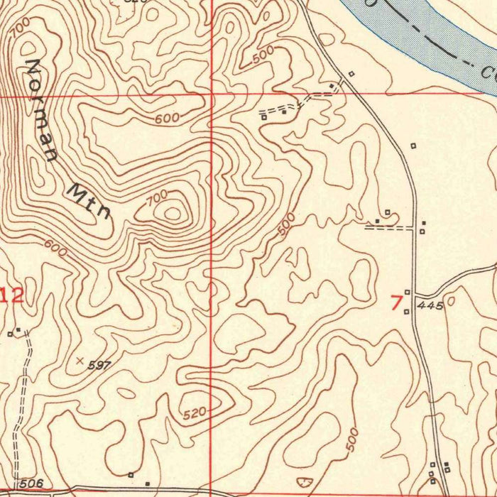
Published in 1952 from 1951 mapping, the U.S. Geological Survey’s “Laniers Quadrangle” presents a finely grained portrait of east-central Alabama’s Coosa River country at a pivotal moment in the region’s modern history. Although today the area is closely associated with Logan Martin Lake, this map captures the landscape in its early-1950s form, before later development and large-scale shoreline transformation reshaped much of the river corridor. At the detailed 1:24,000 scale, the quadrangle records the relationship between settlement, roadways, watercourses, and terrain with the disciplined clarity for which USGS mapping is celebrated. Laniers and the surrounding rural communities appear embedded in a landscape of ridges, hollows, valleys, and winding routes, offering an evocative snapshot of Alabama before the more intensive recreational and residential growth of later decades.
The map’s topographic language is one of its great pleasures: contour lines ripple across the sheet, translating the uplands and lowlands around the Coosa River into a precise visual rhythm. These lines reveal the subtle but consequential relief of the region, where roads follow ridgelines or dip toward creek valleys, and where settlement patterns respond to the practical demands of slope, drainage, and access. Water features stand out as organizing elements, with the Coosa River and its associated streams shaping both the physical landscape and the human geography of the quadrangle. The careful plotting of roads, trails, and scattered infrastructure gives the viewer a sense of movement through the countryside, while the contouring preserves the underlying structure of the land with scientific elegance.
The U.S. Geological Survey, founded in 1879, became the preeminent American institution for mapping the nation’s terrain, water systems, mineral resources, and geological character. By the mid-twentieth century, its 7.5-minute quadrangle maps had become essential tools for engineers, planners, geologists, landowners, hikers, and government agencies alike. The “Laniers Quadrangle” belongs to this great cartographic tradition, combining field survey, aerial interpretation, and standardized symbology into a map designed for both accuracy and readability. Its restrained graphic style—contours, hydrography, roads, place names, and cultural features arranged with quiet precision—reflects the USGS commitment to making complex landscapes legible. For collectors, this institutional pedigree adds significance: the map is not merely decorative, but part of a vast scientific project to measure and describe the American landscape.
Historically, the map is especially compelling because it documents the Coosa River area just before a period of major postwar change in Alabama. The early 1950s saw expanding transportation networks, rural electrification, new patterns of land use, and growing interest in water management and hydroelectric development across the Southeast. In later years, Logan Martin Lake would become one of the defining features of this region, altering shorelines, recreational patterns, and nearby settlement. This quadrangle therefore offers a valuable “before” view: a record of valleys, roads, farms, and riverine terrain as they existed prior to the full impact of reservoir-centered development. It allows modern viewers to compare the remembered or present-day landscape with the carefully surveyed ground of an earlier generation.
As a historical object, the “Laniers Quadrangle” invites close reading. Place names, road alignments, stream courses, and contour intervals together form a layered account of local geography, showing how people lived within the constraints and opportunities of the land. The map’s modest towns and rural routes speak to a quieter Alabama, while the Coosa River hints at the economic and environmental forces that would later transform the area. Its appeal lies in this combination of precision and atmosphere: it is at once a scientific document, a regional history, and a beautifully ordered image of terrain. For anyone with ties to Logan Martin Lake, the Coosa River, or the Laniers area, it offers an unusually intimate window into the landscape’s mid-century past.
Cities, towns and places on this map
- Logan Martin Lake
- Coosa River
- Laniers
- Nearby roads and trails
- Potential infrastructure locations, such as reservoirs or parks
Historical context & cartographic details
- Map Name: Laniers Quadrangle
- Publisher: Produced by the U.S. Geological Survey (USGS)
- Date of Creation: Created in 1951 and published in 1952
- Scale: 1:24,000
- Mapmaker's Context: The USGS is a scientific agency of the U.S. government known for its extensive geological and topographic mapping work.
- Design Characteristics: Features a clear, organized layout typical of mid-20th-century USGS topographic maps.
- Topographic Character: Uses contour lines to show elevation changes, valleys, and water bodies.
- Historical Significance: Represents a snapshot of the area in the early 1950s, likely before substantial development and landscape changes such as urbanization or environmental transformation.
Looking for a particular place? Review the detailed images to confirm that the town, landmark or feature you have in mind appears on the map. If you are unsure, ask our workshop to check before you order.
Detailed maps are especially rewarding at larger sizes, where names, boundaries and decorative features have more room to be appreciated. Use the close-up preview and size guide to choose the right scale for your wall.
This map looks amazing at sizes all the way up to 50in (125cm). If you are looking for a larger map, please get in touch.
The model in the listing images is holding the 16x20in (40x50cm) version of this map.
Where personalisation is available, you can add a short title or dedication, mark one meaningful place, or request one considered visual detail. See personalised map examples.
Every piece is printed to museum-grade archival standards using fade-resistant pigment inks on acid-free matte paper. Choose an unframed map print, framed map or canvas using the finish options above. Framed maps use crystal-clear optical acrylic and arrive ready to hang.
With its rich detail and strong sense of place, this map makes a considered gift for a new home, anniversary, retirement or anyone with a personal connection to the area shown. Still deciding? Explore our collection of rare old and vintage maps to discover another place, period or style.
Share