The Unique Maps Co.
Old Map of Inverness, California by USGS, 1916 – Point Reyes National Seashore, Point Reyes Station & Tomales Bay
Old Map of Inverness, California by USGS, 1916 – Point Reyes National Seashore, Point Reyes Station & Tomales Bay
Não foi possível carregar a disponibilidade de retirada.
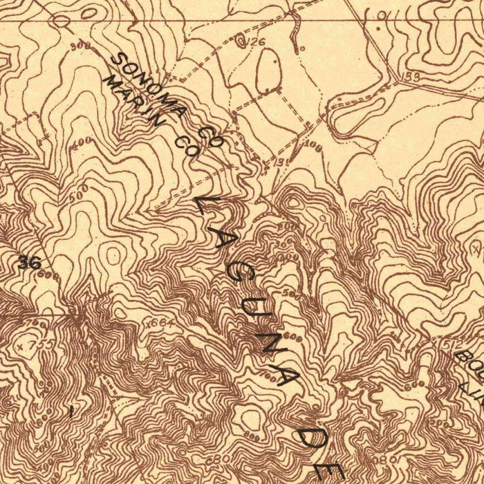
Published in 1916 by the United States Geological Survey, “Point Reyes” is an evocative advance topographical map of one of California’s most dramatic coastal landscapes. At a scale of 1:48,000, it records Inverness, Point Reyes Station, Tomales Bay, Drakes Bay, and the wind-carved headlands before the area became widely known as Point Reyes National Seashore. The map’s fine 25-foot contour intervals give the terrain a sculptural clarity, tracing ridges, valleys, bluffs, and shorelines with scientific precision. In its restrained brown cartographic style, the landscape appears both measured and atmospheric, capturing a moment when Marin County’s coast was still defined by ranches, tidal waters, wooded slopes, and small settlements.
The US Geological Survey was established in 1879 to classify public lands, investigate geological structure, and document the natural resources of the United States. By the early twentieth century, its topographic sheets had become indispensable tools for engineers, land managers, scientists, and travelers. This 1916 Point Reyes sheet reflects that mission with unusual elegance: it is practical, empirical, and quietly beautiful. The “advance” designation suggests a working map issued ahead of a final series publication, making it especially revealing as a record of survey knowledge in progress. Every contour, stream course, road, and settlement is part of a larger national effort to render the American landscape legible.
Point Reyes itself is a place of striking geographical drama, and the map makes that drama visible. The peninsula thrusts into the Pacific beside the long sheltered waters of Tomales Bay, its exposed outer coast shaped by surf, fog, wind, and tectonic force. Drakes Bay and Drakes Estero appear as sheltered maritime spaces, recalling the deep history of exploration, navigation, and coastal encounter associated with Sir Francis Drake. Inland, the map follows the folds of Olema Valley and the rising ground around Inverness Park and Nicasio. The dense contouring conveys how abruptly the land rises from beaches, lagoons, and estuaries into rugged coastal uplands.
The towns and hamlets on the map speak to a quieter human history. Inverness appears as a small coastal settlement poised beside Tomales Bay, long prized for its seclusion, views, and proximity to forest and water. Point Reyes Station, meanwhile, is shown as a modest inland hub, tied to agriculture, dairying, transport, and the rural economy of western Marin. Nearby features such as Chicken Ranch Beach, Bolinas Lagoon, and the future Giacomini Wetlands evoke a landscape where tidal ecology and working land overlapped. The map predates modern conservation designations, making it a fascinating witness to the region before its later transformation into a celebrated protected seashore.
As a historical document, the 1916 Point Reyes map invites comparison between past and present. The landforms remain elemental—headlands, bays, beaches, valleys—but the meanings attached to them have changed profoundly through conservation, recreation, ecological restoration, and shifting patterns of settlement. Areas now associated with hiking routes such as the Coast Trail, with Limantour Beach, and with the biodiversity of Point Reyes National Seashore were here recorded primarily as terrain: measured elevations, waterways, roads, and place names. That tension between scientific restraint and natural grandeur gives the map its enduring appeal. It preserves the California coast at a precise historical moment, both surveyed and still wonderfully wild.
Cities, towns and places on this map
- Inverness
- Point Reyes National Seashore
- Point Reyes Station
- Drakes Bay
- Tomales Bay
- Point Reyes Headlands
- Limantour Beach
- Giacomini Wetlands
- Olema Valley
- Inverness Park
- Nicasio
- Marin Headlands
- Coast Trail
- Drakes Estero
- Bolinas Lagoon
- Chicken Ranch Beach
- Sir Francis Drake Hotel (historical context)
- Sir Francis Drake Inlet (historical context)
Historical context & cartographic details
- Published by the US Geological Survey (USGS), an agency established to survey and document the nation’s geological, geographic, hydrologic, and natural resources.
- Dated 1916, the map records the Point Reyes area as it appeared in the early 20th century.
- Produced at a scale of 1:48,000.
- Identified as an advance topographical map.
- Uses brown ink on a light background to emphasize topographical detail.
- Shows contour lines at 25-foot intervals, clearly illustrating hills, valleys, and elevation changes.
- Offers historical insight into land development, conservation, and environmental change in the Point Reyes region over time.
Looking for a particular place? Review the detailed images to confirm that the town, landmark or feature you have in mind appears on the map. If you are unsure, ask our workshop to check before you order.
Detailed maps are especially rewarding at larger sizes, where names, boundaries and decorative features have more room to be appreciated. Use the close-up preview and size guide to choose the right scale for your wall.
This map looks amazing at sizes all the way up to 50in (125cm). If you are looking for a larger map, please get in touch.
The model in the listing images is holding the 36x24in (90x60cm) version of this map.
Where personalisation is available, you can add a short title or dedication, mark one meaningful place, or request one considered visual detail. See personalised map examples.
Every piece is printed to museum-grade archival standards using fade-resistant pigment inks on acid-free matte paper. Choose an unframed map print, framed map or canvas using the finish options above. Framed maps use crystal-clear optical acrylic and arrive ready to hang.
With its rich detail and strong sense of place, this map makes a considered gift for a new home, anniversary, retirement or anyone with a personal connection to the area shown. Still deciding? Explore our collection of rare old and vintage maps to discover another place, period or style.
Share