The Unique Maps Co.
Old Map of Clarkdale, Arizona by USGS, 1973 – Verde River, Cottonwood & Mingus Mountain
Old Map of Clarkdale, Arizona by USGS, 1973 – Verde River, Cottonwood & Mingus Mountain
Não foi possível carregar a disponibilidade de retirada.
Published in 1977 from 1973 survey work, the US Geological Survey’s “Clarkdale” presents a finely measured portrait of Arizona’s Verde Valley at the authoritative 1:24,000 scale. Centered on Clarkdale and its surrounding uplands, the map captures a landscape where settlement, industry, river corridor, and rugged terrain meet. The Verde River threads through the composition in crisp blue, while roads, railroads, and town grids reveal the human framework imposed upon a dramatic natural setting. As a historical document of the early 1970s, it preserves a moment before later waves of regional growth reshaped parts of central Arizona, making it especially compelling for those interested in land use, transportation, and the evolution of desert-edge communities.
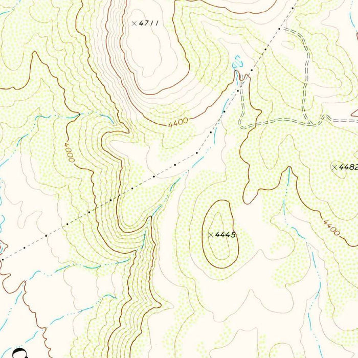
The US Geological Survey’s disciplined cartographic style gives this map its enduring elegance. Founded in the late nineteenth century, the USGS became the nation’s great scientific mapper, producing quadrangles that served engineers, geologists, planners, hikers, and public agencies alike. Here, that institutional clarity is visible in every symbol: contour lines articulate the rise and fall of the land, blue hydrography distinguishes rivers and creeks, and carefully coded roads and rail lines organize movement across the valley. Unlike decorative atlas maps, the beauty of this sheet lies in precision. It is a technical landscape rendered with restraint, yet the result is visually rich—a dense, legible record of topography, infrastructure, and environmental form.
Clarkdale itself occupies a historically resonant position in the Verde Valley. Developed in the early twentieth century as a planned smelter town tied to Arizona’s copper economy, it stands near the Verde River and beneath the broader shadow of Mingus Mountain. The surrounding terrain shown on the map speaks to that industrial and logistical past: railroads trace practical routes through the valley, roads connect Clarkdale with Cottonwood and the wider region, and the river corridor anchors agriculture, settlement, and transport. U.S. Route 89A, one of northern Arizona’s notable highways, links the area to high country, mining districts, red-rock country, and the tourist routes that increasingly defined the region in the late twentieth century.
The topographic character is one of the map’s great pleasures. Closely spaced contour lines climb toward the hilly and mountainous country associated with Mingus Mountain, while gentler spacing marks the valley floor around Clarkdale and Cottonwood. This contrast makes the sheet immediately readable: steep slopes, ridges, washes, and canyon margins emerge through the geometry of elevation. The Verde River and smaller creeks provide a sinuous counterpoint to the angularity of roads and section lines, emphasizing the way water has shaped settlement in an otherwise demanding landscape. Nearby valleys, unnamed peaks, and canyon areas give the map a sense of depth and motion, turning a local quadrangle into a study of geological drama.
Beyond Clarkdale, the map evokes the wider geography of central Arizona, with Cottonwood, routes toward Sedona, and the Coconino National Forest all suggesting the transition from river valley to high plateau and red-rock country. It records a region at an intriguing historical threshold: still marked by mining heritage, rail connections, and compact towns, yet increasingly connected to recreation, scenic travel, and suburban expansion. For collectors, historians, and admirers of the American Southwest, this USGS sheet offers more than coordinates. It is a lucid, data-rich image of place—where hydrology, elevation, settlement, and history converge in the Verde Valley’s distinctive terrain.
Cities, towns and places on this map
- Clarkdale
- Verde River
- Mingus Mountain
- Cottonwood
- Sedona
- Coconino National Forest
- Various unnamed peaks and hills
- Major highways and roads, including U.S. Route 89A
- Nearby valleys and canyon areas
- Railroads in the vicinity
- Water bodies, including lakes and smaller creeks
Historical context & cartographic details
- Produced by the US Geological Survey, this historical 1:24,000 topographical map shows Clarkdale, Arizona, and the surrounding area.
- The map is dated 1973 and carries a 1977 imprint.
- Published by the US Geological Survey, renowned for its comprehensive mapping and geological surveys across the United States.
- The map uses contour lines to represent elevation and changes in terrain.
- Hydrographic features, including rivers and streams, are marked in blue.
- The terrain is hilly, with significant elevation changes shown by closely spaced contour lines.
- The map reflects the early 1970s topography of the Clarkdale area.
- It offers historical insight into changes in land use, urban development, settlement patterns, and land utilization over time.
Looking for a particular place? Review the detailed images to confirm that the town, landmark or feature you have in mind appears on the map. If you are unsure, ask our workshop to check before you order.
Detailed maps are especially rewarding at larger sizes, where names, boundaries and decorative features have more room to be appreciated. Use the close-up preview and size guide to choose the right scale for your wall.
This map looks amazing at sizes all the way up to 50in (125cm). If you are looking for a larger map, please get in touch.
The model in the listing images is holding the 16x20in (40x50cm) version of this map.
Where personalisation is available, you can add a short title or dedication, mark one meaningful place, or request one considered visual detail. See personalised map examples.
Every piece is printed to museum-grade archival standards using fade-resistant pigment inks on acid-free matte paper. Choose an unframed map print, framed map or canvas using the finish options above. Framed maps use crystal-clear optical acrylic and arrive ready to hang.
With its rich detail and strong sense of place, this map makes a considered gift for a new home, anniversary, retirement or anyone with a personal connection to the area shown. Still deciding? Explore our collection of rare old and vintage maps to discover another place, period or style.
Share