The Unique Maps Co.
Old Map of Chesapeake City, Maryland by USGS, 1942 – North East, Elkton & Bohemia River
Old Map of Chesapeake City, Maryland by USGS, 1942 – North East, Elkton & Bohemia River
Não foi possível carregar a disponibilidade de retirada.
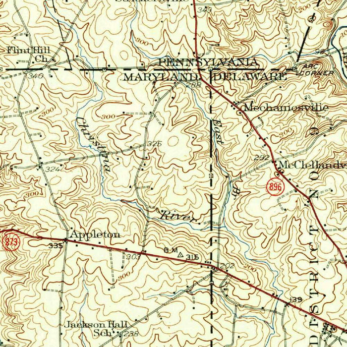
Published in 1942 by the United States Geological Survey, “Elkton” presents a finely detailed topographical portrait of northeastern Maryland at a pivotal moment in the region’s modern history. At a scale of 1:62,500, the map captures Chesapeake City, North East, Elkton, and the surrounding countryside with the precision for which the USGS became renowned. This is a landscape shaped by water, roads, and low, rolling elevations: a meeting ground between the Chesapeake Bay watershed and the routes leading toward Delaware. The original title’s simplicity belies the richness of the sheet, which records not only towns and transportation corridors, but also the subtle physical structure of the land as it appeared in the early 1940s.
The US Geological Survey brought to this map its characteristic union of scientific accuracy and understated graphic elegance. Elevation contours spread across the sheet in rhythmic lines, revealing the hilly terrain and shallow valleys that define the area around Elkton, Chesapeake City, and North East. The effect is almost sculptural, giving the viewer a sense of three-dimensional landform through linework alone. Roadways, shown in red, provide a vivid counterpoint to the quieter contouring and hydrographic detail, tracing the arteries of local movement through farmland, settlement, and river country. This is the USGS style at its most useful and beautiful: empirical, legible, and deeply attentive to the texture of place.
Water is the great organizing presence of the map. The Sassafras River, Bohemia River, and surrounding creeks and inlets shape the geography with sinuous authority, while Chesapeake City stands out as a strategically important community amid a network of navigable waterways. North East appears in relation to the headwaters and shorelines that long influenced settlement, commerce, and travel in Cecil County. The map also situates the area within the broader hydrological world of the upper Chesapeake and the Delaware River approaches, where rivers, canals, and overland roads connected rural Maryland to larger Atlantic trade routes. These waterways are not decorative features; they are the historical framework of the region.
The 1942 date lends the map particular historical resonance. It records the landscape during the early years of American involvement in the Second World War, when transportation networks, bridges, waterways, and industrial access carried heightened strategic importance. Summit Bridge and the road systems shown in red speak to a region increasingly defined by mobility and infrastructure, yet still anchored in agricultural land, small towns, and riverine geography. Comparing this view with the modern landscape reveals decades of suburban growth, changes in land use, expanded road corridors, and evolving waterway management. The map is therefore both a practical survey and a time capsule of northeastern Maryland before the postwar transformation accelerated.
As a topographical composition, “Elkton” rewards close study. The contours reveal subtle uplands and drainage patterns, while the towns and roads show how human settlement adapted to the terrain. Chesapeake City and North East appear not as isolated names, but as parts of a carefully mapped regional system: rivers guiding movement, roads binding communities, and elevations quietly determining the form of fields, villages, and crossings. The result is a map of unusual charm and historical depth, equally compelling for collectors interested in Maryland, Chesapeake geography, USGS cartography, or early twentieth-century American landscapes. It preserves a moment when the physical and human geography of the region could still be read with remarkable clarity.
Cities, towns and places on this map
- Chesapeake City
- North East
- Elkton
- Delaware River
- Sassafras River
- Bohemia River
- Summit Bridge
- Surrounding land around the waterways
- Roadways depicted in red
- Elevation contours throughout the area
- Water bodies and land features around Chesapeake City and North East
Historical context & cartographic details
- Produced by the US Geological Survey
- Historical topographical map of Chesapeake City, North East, Elkton, and the surrounding Maryland area
- Dated 1942
- Published by the US Geological Survey, known for detailed survey-based maps of the United States
- Scale of 1:62,500, providing a detailed view of terrain and local features
- Contours and shading illustrate elevation changes, creating a three-dimensional effect
- Shows hilly terrain, waterways, urban areas, and infrastructure
- Reflects the landscape and infrastructure of the early 1940s
- Useful for observing later changes in urban development, land use, and waterway management
Looking for a particular place? Review the detailed images to confirm that the town, landmark or feature you have in mind appears on the map. If you are unsure, ask our workshop to check before you order.
Detailed maps are especially rewarding at larger sizes, where names, boundaries and decorative features have more room to be appreciated. Use the close-up preview and size guide to choose the right scale for your wall.
This map looks amazing at sizes all the way up to 50in (125cm). If you are looking for a larger map, please get in touch.
The model in the listing images is holding the 16x20in (40x50cm) version of this map.
Where personalisation is available, you can add a short title or dedication, mark one meaningful place, or request one considered visual detail. See personalised map examples.
Every piece is printed to museum-grade archival standards using fade-resistant pigment inks on acid-free matte paper. Choose an unframed map print, framed map or canvas using the finish options above. Framed maps use crystal-clear optical acrylic and arrive ready to hang.
With its rich detail and strong sense of place, this map makes a considered gift for a new home, anniversary, retirement or anyone with a personal connection to the area shown. Still deciding? Explore our collection of rare old and vintage maps to discover another place, period or style.
Share