The Unique Maps Co.
Old Map of Cayucos, California by USGS, 1951 – Morro Bay & Morro Rock
Old Map of Cayucos, California by USGS, 1951 – Morro Bay & Morro Rock
Não foi possível carregar a disponibilidade de retirada.
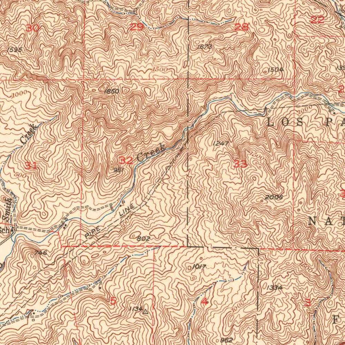
Published in 1953 from 1951 mapping, the USGS “Cayucos Quadrangle” presents a finely observed mid-century portrait of California’s central coast, centered on Cayucos, Morro Bay, and the dramatic meeting of coastal hills with the Pacific Ocean. At a 1:62,500 scale, the map captures the region with the clarity and discipline for which the United States Geological Survey became renowned: contour lines articulate steep slopes and rolling uplands, while color differentiations help distinguish landforms, water, and developed corridors. It is a map of transition, showing a coastline already threaded by Highway 1 and rail lines, yet still visibly shaped by ranchlands, valleys, headlands, and the powerful geography that constrained and guided settlement.
The USGS was, by the time this map appeared, the preeminent scientific mapping institution in the United States, producing topographical sheets essential to engineers, planners, geologists, navigators, and public agencies. Its quadrangle maps combined field survey, geodetic control, and standardized cartographic design to create a national visual language of terrain. In the “Cayucos Quadrangle,” that language is especially expressive: the dense, curling contour lines along hills and cliffs contrast with the open expanse of the Pacific, making the coastal relief immediately legible. The map is not merely a guide to places, but a scientific rendering of how land rises, drains, erodes, and meets the sea along one of California’s most distinctive shorelines.
Cayucos appears here as a compact coastal community set against the sweep of Estero Bay, a place historically associated with fishing, ranching, and seaside travel. To the south, Morro Bay is anchored by the unmistakable presence of Morro Rock, the volcanic plug that has long served as a landmark for mariners and travelers. The map’s topography emphasizes why this landscape is so memorable: oceanfront lowlands quickly give way to hills, ridges, and rugged inland folds. Nearby names such as Green Valley, Piney Point, and Cerro Cabrillo add texture to the scene, evoking a coast where Spanish place names, natural features, and twentieth-century infrastructure coexist in close proximity.
The broader geography shown on the sheet extends beyond picturesque towns to a layered coastal environment of bays, points, valleys, and transportation routes. Estero Bay and San Luis Obispo Bay frame the maritime setting, while Los Osos and Woodlands Park suggest the expanding settlement patterns of the postwar era. Highway 1, one of California’s great scenic routes, is visible as a crucial north-south thread connecting communities along the coast. Railroad tracks further reveal the older logistical framework of the region, tying coastal settlements to agricultural and military landscapes inland. Camp San Luis Obispo marks another dimension of mid-century California, when military installations, civic growth, and coastal tourism all left their imprint on the map.
As a historical document, the “Cayucos Quadrangle” preserves the central coast before later waves of suburban expansion, environmental regulation, and intensified tourism transformed the region’s appearance and use. Its careful contouring records not only elevations but possibilities: where roads could climb, where towns could spread, where watersheds descended toward the sea, and where cliffs and hills resisted easy development. Morro Bay’s vibrant estuarine ecosystem, today widely recognized for its ecological importance, is shown within a landscape still comparatively open and lightly urbanized. The result is a compelling mid-twentieth-century snapshot of coastal California—precise, understated, and rich with the geographic character that continues to define Cayucos, Morro Bay, and their surrounding shores.
Cities, towns and places on this map
- Cayucos
- Morro Bay
- Estero Bay
- Pacific Ocean
- Morro Rock
- Green Valley
- Los Osos
- San Luis Obispo Bay
- Punta de los Reyes
- Camp San Luis Obispo
- Cerro Cabrillo
- Piney Point
- Woodlands Park
- Highway 1
- Railroad tracks
- Various contour lines indicating elevation changes
Historical context & cartographic details
- Map title: Cayucos Quadrangle
- Created: 1951, with a 1953 imprint
- Mapmaker/Publisher: United States Geological Survey (USGS)
- Scale: 1:62,500
- Map type: Historical topographical quadrangle map
- The USGS was central to mapping and surveying the United States, producing detailed topographical maps used for navigation, land planning, geological research, and public works.
- The map uses varied colors to distinguish elevations, landforms, and other geographic features.
- Prominent contour lines show changes in terrain elevation across the coastal landscape.
- The terrain shown includes rugged coastal hills and cliffs beside the smoother expanse of the ocean.
- The map reflects mid-20th-century coastal development in California.
- It provides a geographic snapshot of the area before later urban growth and environmental changes.
Looking for a particular place? Review the detailed images to confirm that the town, landmark or feature you have in mind appears on the map. If you are unsure, ask our workshop to check before you order.
Detailed maps are especially rewarding at larger sizes, where names, boundaries and decorative features have more room to be appreciated. Use the close-up preview and size guide to choose the right scale for your wall.
This map looks amazing at sizes all the way up to 50in (125cm). If you are looking for a larger map, please get in touch.
The model in the listing images is holding the 16x20in (40x50cm) version of this map.
Where personalisation is available, you can add a short title or dedication, mark one meaningful place, or request one considered visual detail. See personalised map examples.
Every piece is printed to museum-grade archival standards using fade-resistant pigment inks on acid-free matte paper. Choose an unframed map print, framed map or canvas using the finish options above. Framed maps use crystal-clear optical acrylic and arrive ready to hang.
With its rich detail and strong sense of place, this map makes a considered gift for a new home, anniversary, retirement or anyone with a personal connection to the area shown. Still deciding? Explore our collection of rare old and vintage maps to discover another place, period or style.
Share