The Unique Maps Co.
Old Map of Calico Rock, Arkansas by USGS, 1894 – White River & Ozark Mountains
Old Map of Calico Rock, Arkansas by USGS, 1894 – White River & Ozark Mountains
Não foi possível carregar a disponibilidade de retirada.
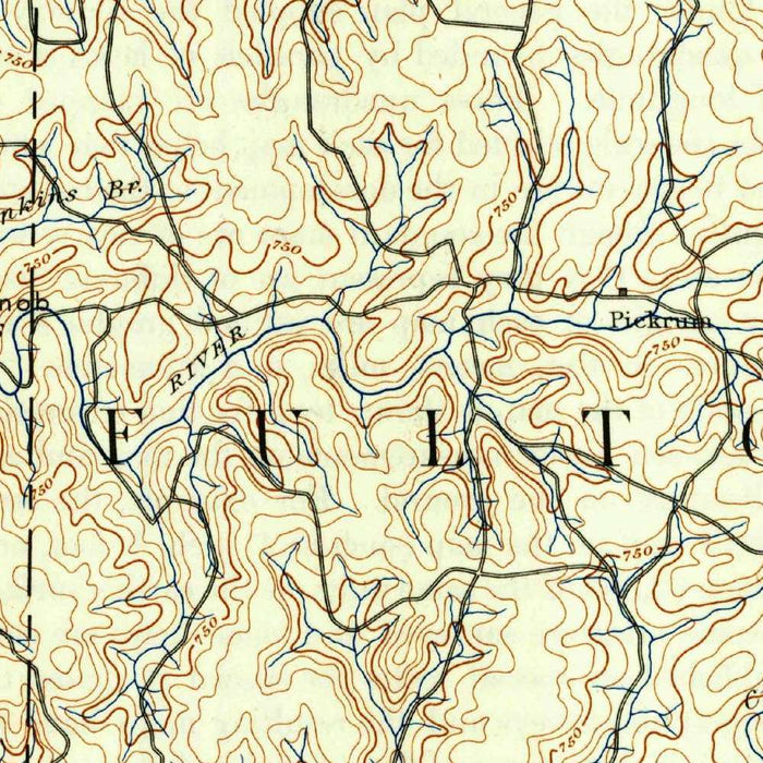
The United States Geological Survey’s “Mountain Home” presents the Calico Rock region of Arkansas with the precision and quiet authority of a late nineteenth-century topographical survey. Dated 1894 and carrying a 1944 imprint, it brings forward an earlier record of the landscape at a 1:125,000 scale, preserving the geography of the Ozark country as it was understood during a formative period of American mapping. Calico Rock appears near the White River, set amid a terrain of ridges, valleys, wooded slopes, and scattered rural settlements. The title evokes the broader Mountain Home quadrangle, but the map’s appeal lies equally in its intimate attention to creeks, roads, trails, and the subtle patterns of upland Arkansas life.
Created by the United States Geological Survey, this map belongs to one of the great national cartographic projects of the modern era. Founded in 1879, the USGS was charged with classifying public lands, studying geological resources, and producing dependable maps for government, industry, science, and settlement. Its topographical sheets became indispensable tools for engineers, foresters, miners, travelers, and local officials. In “Mountain Home,” that institutional rigor is evident in the careful contouring, measured hydrography, and systematic portrayal of transportation routes. Rather than a decorative fantasy of the landscape, it is a disciplined scientific portrait—yet one whose dense lines and restrained colors give the Ozark terrain an austere, compelling beauty.
The map’s topographical design is especially evocative, using contour lines to translate the rolling and broken landforms of the Ozark Mountains into a readable visual language. Elevation changes ripple across the sheet in fine, disciplined curves, revealing hillsides, hollows, ridgelines, and stream-cut valleys. Color distinctions clarify water, vegetation, and terrain, while roads and trails trace the human response to the land’s natural obstacles. This is a region where geography dictates movement: paths follow valleys, settlements gather near water, and the White River becomes both landmark and lifeline. The overall effect is not merely informational, but atmospheric—a cartographic rendering of ruggedness, remoteness, and rural endurance.
Calico Rock, one of the notable places shown, occupies a particularly picturesque setting along the White River. Long associated with dramatic bluffs, river views, and Ozark scenery, the town’s position made it a focal point in a landscape defined by watercourses and wooded slopes. Nearby Lizard Creek, South Fork, and numerous smaller streams branch through the countryside, carving valleys and sustaining pockets of settlement. The map also records unnamed villages, rural roads, and trails, offering glimpses of a dispersed agrarian world before modern infrastructure fully transformed the region. For collectors drawn to maps as records of place, these modest details are often among the most revealing.
Historically, “Mountain Home” captures Arkansas during an era of transition, when land use, transportation, and population patterns were evolving across the interior United States. The late nineteenth-century survey reflects a landscape still deeply rural, shaped by forests, rivers, small communities, and the difficult terrain of the Ozarks. By the time of the 1944 imprint, the nation had changed dramatically, yet the map preserved an earlier geographical framework with lasting practical value. Its layered chronology gives it unusual interest: a nineteenth-century understanding of the land carried into the mid-twentieth century. As a study of terrain, settlement, and institutional mapmaking, it is both scientifically exacting and richly historical.
Cities, towns and places on this map
- Calico Rock
- White River
- Lizard Creek
- South Fork
- Ozark Mountains
- Various unnamed villages and rural areas
- Roads
- Trails
- Lakes and streams in the vicinity
Historical context & cartographic details
- Map name: Mountain Home
- Produced by the United States Geological Survey (USGS)
- Historical 1:125,000 topographical map showing Calico Rock, Arkansas, and the surrounding area
- Dated 1894 with a 1944 imprint
- The USGS has produced detailed maps and geological information since its establishment in 1879
- Uses contour lines to illustrate elevation changes
- Color scheme highlights terrain features, water bodies, and vegetation
- Shows the rolling hills, valleys, rivers, and dense forests characteristic of the Ozark region
- Reflects geographical understanding of the area from the late 19th to mid-20th century
- Captures a period of changing land use and population distribution in the United States
Looking for a particular place? Review the detailed images to confirm that the town, landmark or feature you have in mind appears on the map. If you are unsure, ask our workshop to check before you order.
Detailed maps are especially rewarding at larger sizes, where names, boundaries and decorative features have more room to be appreciated. Use the close-up preview and size guide to choose the right scale for your wall.
This map looks amazing at sizes all the way up to 50in (125cm). If you are looking for a larger map, please get in touch.
The model in the listing images is holding the 16x20in (40x50cm) version of this map.
Where personalisation is available, you can add a short title or dedication, mark one meaningful place, or request one considered visual detail. See personalised map examples.
Every piece is printed to museum-grade archival standards using fade-resistant pigment inks on acid-free matte paper. Choose an unframed map print, framed map or canvas using the finish options above. Framed maps use crystal-clear optical acrylic and arrive ready to hang.
With its rich detail and strong sense of place, this map makes a considered gift for a new home, anniversary, retirement or anyone with a personal connection to the area shown. Still deciding? Explore our collection of rare old and vintage maps to discover another place, period or style.
Share